Chicago, located in the United States’ Midwest, is the country’s third-largest city. It is renowned for its rich cultural heritage, iconic landmarks, and vibrant art scene. As a popular tourist destination, many visitors explore the city’s architectural wonders, indulge in delicious cuisine, and visit world-famous museums and art institutions. For independent travellers, public transportation, particularly the subway station system, is the most convenient way to get around Chicago. This blog will provide a comprehensive guide to navigating the Chicago subway map in 2024, including routes, operating hours, fare information, ticketing options, and precations.
1.Introduction to Chicago Subway
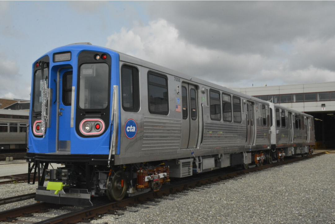
Chicago’s transportation system is primarily managed by the Chicago Transit Authority (CTA), the second-largest public transportation system in the United States. The Chicago subway, commonly known as the “L” (short for “elevated”), is one of the most iconic and frequently used modes of transportation in the city. It encircles the downtown area, known as the Loop, with multiple lines converging at the centre, providing easy access to almost any destination within Chicago.
Chicago’s first elevated rail line began operating on June 6, 1892. The current subway system consists of eight high-capacity rail lines totalling 106.1 miles in length. Of these, 57.1 miles are elevated, 36.9 miles are at ground level, and 12.1 miles are underground. Chicago subway map system ranks fourth in the United States regarding total route length, following the subway systems in New York City, Washington, D.C., and the San Francisco Bay Area.
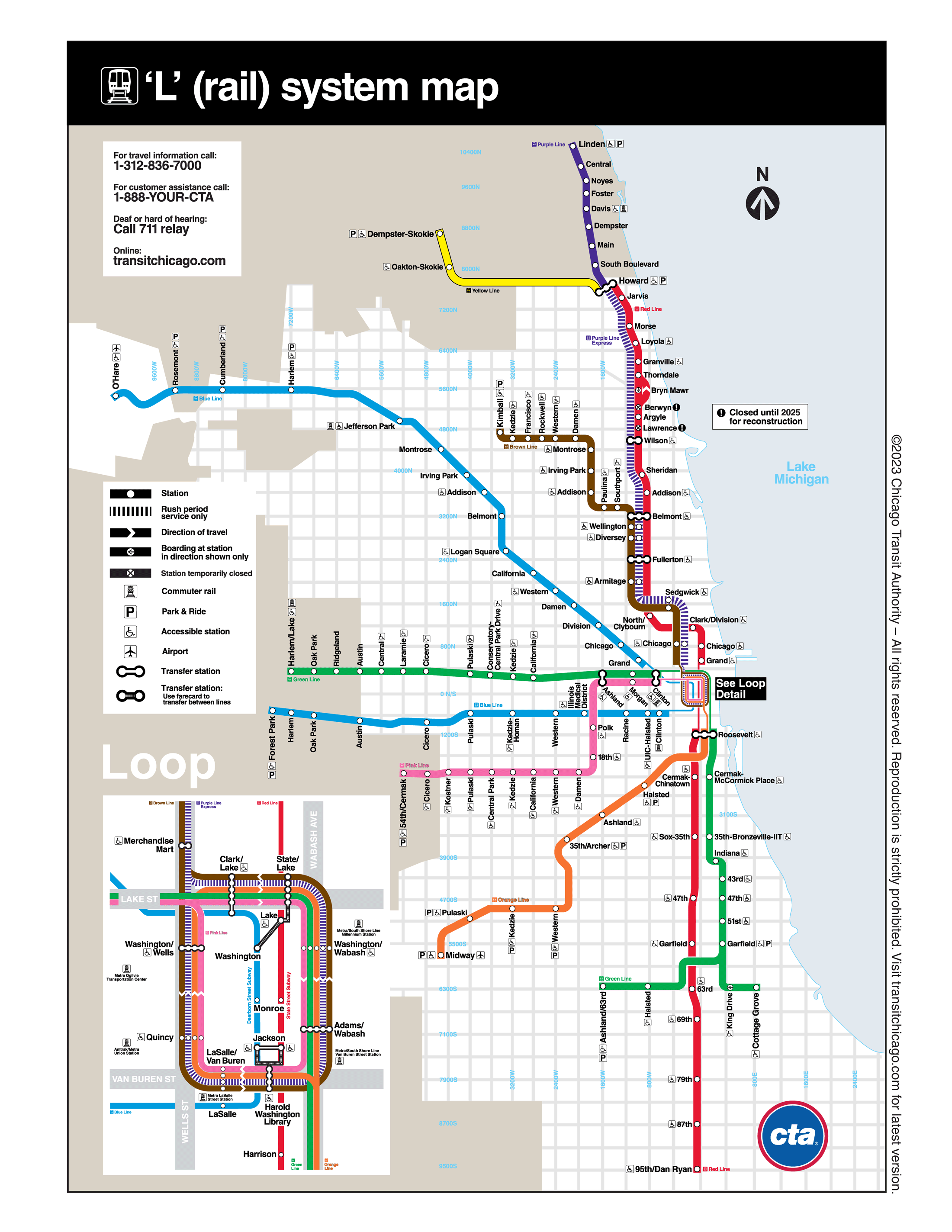
The chicago subway system extends from the north to the south of the city, serving various neighbourhoods and covering a significant portion of the urban area. The Chicago CAT subway map have advertisements, maps, and station signage for convenient navigation. Additionally, the stations provide services such as wheelchair accessibility and designated areas for strollers and bicycles to accommodate passengers with special needs.
2. Chicago Subway Lines
The Chicago CTA subway map consists of eight lines, each designated by a different color: Red, Blue, Brown, Green, Orange, Purple, Pink, and Yellow. The Red, Blue, and Brown lines are the main routes of the L system and serve as major transportation hubs within the city center. While the Red and Blue lines predominantly operate underground in downtown areas, the rest of the lines primarily run on elevated tracks or at ground level.
The subway lines in Chicago cover a vast majority of the city and its suburbs, making it convinent to explore most popular tourist attractions.
| Line | Length Overall | Travel Range | Major Interchange |
|---|---|---|---|
| Red Line | 35km | Howard – 95th Street / Dan Ryan | Howard -transfer to Yellow and Purple Lines Wilson – transfer to Purple Line Fullerton – transfer to Purple and Brown lines Roosevelt – transfer to Orange Line, Green Line Howard -transfer to Yellow and Purple Lines Wilson – transfer to Purple Line Fullerton – transfer to Purple and Brown lines Roosevelt – transfer to Orange Line, Green Line |
| Blue Line | 43km | O’Hare Airport – Racine – Forest Park | Jefferson Park – transfer to Chicago Commuter Rail Union Pacific/Northwest Line Irving Park – transfer to Chicago Commuter Rail Union Pacific/Northwest Line Clark/Lake – transfer to Orange, Green, Purple, Brown and Pink Lines Washington Station – transfer to Red Line |
| Brown Line | 18km | Kimball – Clark/Lake | Clark/Lake Station – transfer to Orange, Green, Purple, Blue and Pink Lines State/Lake – transfer to Red Line Washington/Wabash – transfer to Chicago Commuter Rail Metra Line (Millennium Station), South Shore Line (Millennium Station) Adams/Wabash-transfer to Orange, Green, Purple, Pink Lines Harold Washington Library – State/Van Buren – transfer to Orange Line, Purple Line, Pink Line, Red Line (Jackson/State), Blue Line (Jackson/Dearborn) LaSalle/Van Buren – transfer to Chicago Commuter Railway Rock Island Line (LaSalle Street Station) Damen – transfer to Union Pacific/North Line (Ravenswood) Belmont – transfer to Red Line, Purple Line Fullerton – transfer to Red and Purple lines Merchandise Mart-transfer to Purple Line Washington/Wells-transfer to Orange, Purple, Pink Lines Clark/Lake Station – transfer to Orange, Green, Purple, Blue and Pink Lines State/Lake – transfer to Red Line Washington/Wabash – transfer to Chicago Commuter Rail Metra Line (Millennium Station), South Shore Line (Millennium Station) Adams/Wabash-transfer to Orange, Green, Purple, Pink Lines Harold Washington Library – State/Van Buren – transfer to Orange Line, Purple Line, Pink Line, Red Line (Jackson/State), Blue Line (Jackson/Dearborn) LaSalle/Van Buren – transfer to Chicago Commuter Railway Rock Island Line (LaSalle Street Station) Damen – transfer to Union Pacific/North Line (Ravenswood) Belmont – transfer to Red Line, Purple Line Fullerton – transfer to Red and Purple lines Merchandise Mart-transfer to Purple Line Washington/Wells-transfer to Orange, Purple, Pink Lines |
| Green Line | 33.5km | Harlem/Lake – Ashland/63rd St. | Harlem/Lake – transfer to Chicago Commuter Rail Union Pacific/Western (Oak Park) Kedzie – transfer to Chicago Commuter Rail Union Pacific/Western (Kedzie) Ashland – transfer to Pink Line Clinton – transfer to Pink Line, Chicago Commuter Rail Union Pacific/North, Union Pacific/Northwest, Union Pacific/West (Ogilvie Transfer Center) |
| Orange Line | 21km | Midway-Adams/Wabash | Adams/Wabash-transfer to Purple, Green, Brown, and Pink Lines Washington/Wabash-transfer to Chicago Commuter Rail Metra Electric Line (Millennium Station), South Shore Line (Millennium Station) Clark/Lake-transfer Purple, Green, Blue, Brown, Pink Lines |
| Purple Line | 6km | Linden-Washington/Wells | Davis – transfer to Union Pacific/North Line (Davis Street, Evanston) Main – transfer to Union Pacific/North Line (Main Street, Evanston) Howard-transfer to Red and Yellow lines Belmont-transfer to Red, Brown Line Fullerton-transfer to Red Line, Brown Line |
| Pink Line | 18km | 54th/Cermak-Washington/Wells | Cicero – transfer to Chicago Commuter Rail BNSF Railway (Cicero Station) Western – transfer to Chicago Commuter Rail BNSF Railway (Western Avenue) Ashland-transfer to Green Line |
| Yellow Line | 8km | Dempster-Skokie—Oakton-Skokie—Howard | Howard-Transfer to Red Line, Purple Line |
3. Chicago Subway Operating Hours and Schedules
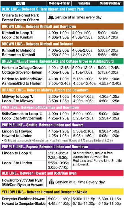
The operating hours of the Chicago subway map vary depending on the specific line, with different frequencies during the day. Typically, trains run every 7-10 minutes during daytime hours and every 10-15 minutes during the evening. The Red and Blue lines operate 24/7, similar to the New York City subway, with no interruptions throughout the year. Let’s take a look at the operating hours for each line:
4. Chicago Subway Ticket Types and Prices:
a. Regular Fares:
Adult Fare: $2.50 per ride
Reduced Fare: $1.25 per ride
Student Fare: $0.75 per ride
When using single-ride tickets on the Chicago subway, passengers can transfer for free within a two-hour window.
b. Passes:
Passes are available for unlimited rides on both buses and subways within a specified time period. The following options are available:
| PASSES Unlimited rides for a period of time from first use.1-Day = 24 hrs, etc. Valid on CTA and Pace. (load onto Ventra account) | Full | Reduced |
|---|---|---|
| 1-Day CTA/Pace Pass | $5 | |
| 3-Day CTA/Pace Pass | $15 | |
| 7-Day CTA/Pace Pass | $20 | |
| 30-Day CTA/Pace Pass | $60 | $30**. |
If you are in Chicago for a long period of time, it is recommended that you purchase a pass, as a one-way ticket is the least cost-effective option. One-way passes can be purchased with cash right at the kiosk, and 1-day, 3-day, and 7-day passes must be loaded onto a Ventra Card to be used, which also supports Apple/Google Pay.
Ventra is the electronic payment system of the Chicago Transit Authority and Pace.Ventra is operated by Cube Transit Systems. The mobile app allows users to manage fares, purchase monthly passes, and purchase mobile tickets on Chicago’s urban railroads.
To take Chicago’s public transportation, you first need to purchase a Ventra Card. This card can be purchased at subway stations, train stations, bus stops, and other locations. A $5 deposit is required to purchase a transit card, which can be topped up or used to purchase a variety of ticket types.
Download the Ventra app on your phone to REGISTER your card, and the $5 is refundable to the card, which can then be recharged directly on the mobile app.
5. Precautions about Chicago Subway
- When taking the Chicago subway, it is essential to prioritize your safety. Avoid traveling alone, especially during nighttime hours. Be vigilant against pickpockets and potential thieves.
- Avoid engaging in conversations with strangers and refrain from sharing personal information or displaying valuable items such as wallets and mobile phones.
- Remain cautious and attentive while on the subway, particularly when seated near the doors. Avoid excessive use of mobile devices, especially when occupying a position vulnerable to theft.
- Plan your destinations and routes in advance to ensure you don’t get lost along the way.
- Read station signage carefully and listen to announcements for any updates or changes to the subway map schedule or service disruptions.
FAQ
Two lines operate 24/7: the Blue Line, which connects Chicago O’Hare International Airport and downtown, and the Red Line, with service between the North and South Sides via downtown.
While Chicago has two subway lines, the majority of our trains are either elevated or at grade (at ground level). Today, Chicago is the only city in the U.S. that still has elevated trains in its downtown area.
The Chicago Metra is the city’s commuter rail system. The difference between Chicago Metra and CTA trains is where you’re coming from. CTA trains are for inner-city Chicago travelers, while the Metra is for the suburbs and is most recognizable for its 2-level train cars.
The Green Line operates weekdays from 4 a.m. to 1 a.m., and Saturdays and Sundays from 5 a.m. to 1 a.m. Between Harlem/Lake and Garfield, trains run on a minimum headway of 12 minutes, decreasing to as few as 10 minutes during weekday rush hours.

